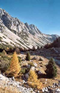
Val Salatis, also known to Alpine skiers, is an alpine valley extending in an East-West direction between the peaks of Mounts Messer and Sestier to the North and the slopes of Mount Guslon to the South. The valley, with a geological matrix of Cretaceous limestone, is characterized by having two quite different opposing slopes. The sunny South-facing slopes have many screes with pioneer Dwarf Mountain Pine (Pinus mugo), isolated Larch and Spruce, and a variety of herbaceous plants belonging to the Seslerio semperviretum association and, at higher levels, to the Caricetum firmae. The north-facing slope, being colder and damper, has a more evolved terrain and Larch-grove type vegetation, dominated by Larch (Larix decidua) with some Spruce (Picea excelsa) and, in the undergrowth, Bilberry (Vaccinium myrtillus), Rhododendron (Rhododendron hirsutum) and Juniper (Juniperus vulgaris). The valley floor, grazed by sheep for centuries, has mostly Nard (Nardus stricta) pasture and the Poaetum alpinae association of grasses. In this environment some typically alpine fauna can be seen such as Eagles, Goshawks, Chamois and Marmots.
There are two trails leaving from Malga Cate and going into Val Salatis. It was in these, now disused, summer pastures that the local race of sheep, the Alpagota, was saved from extinction.
The first, a nature trail, intended for improving environmental awareness, on the screes near Casera Cate (formerly Pal) crosses the land managed in co-operative by families of Lamosano, Molini and Chies d’Alpago. It climbs through the kind of beechwood that colonized abandonned pastures and which is presently coppiced to produce firewood. At the higher parts of the trail the woodland degenerates into pioneer formations of Dwarf Mountain Pine (Pinus mugo) and Larch (Larix decidua).
The second trail leads along Val Salatis through land managed by the families of Lamosano-Molini, notable for its traces of human habitation, examples of rural architecture, and for the natural aspect of coppiced beechwoods.
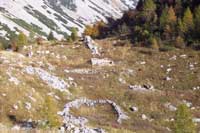
Leaving from Casera Cate you come to the remains of Casera Astor and an egg-shaped sheep pen where the sheep were herded for milking or shearing. Further on there is an old lime kiln, a circular structure of square blocks of stone where quicklime was made. After this on the right you find the barn Campitello, a seasonal shelter for grazing animals, with an old sheep pen. At the end of the trail, you come to the barn Pian de le Stele, at the upper limit of grazing, now used as a shelter by hikers.